2011 Cyclone Yasi
2006 Cyclone Larry
1956 Cyclone Agnes
1986 Cyclone Winifred
1918 Cyclone
Cyclone Before and After Photos
Q150
What is a Tropical Cyclone?
Explanation Bureau of Meteorology
Tropical Cyclones are low pressure systems that form over warm tropical waters and have gale force winds (sustained winds of 63 km/h or greater and gusts in excess of 90 km/h) near the centre. Technically they are defined as a non-frontal low pressure system of synoptic scale developing over warm waters having organised convection and a maximum mean wind speed of 34 knots or greater extending more than half-way around near the centre and persisting for at least six hours.
The gale force winds can extend hundreds of kilometres from the cyclone centre. If the sustained winds around the centre reach 118 km/h (gusts in excess 165 km/h). then the system is called a severe tropical cyclone. These are referred to as hurricanes or typhoons in other countries.
The circular eye or centre of a tropical cyclone is an area characterised by light winds and often by clear skies. Eye diameters are typically 40 km but can range from under 10 km to over 100 km. The eye is surrounded by a dense ring of cloud about 16 km high known as the eye wall which marks the belt of strongest winds and heaviest rainfall.
Tropical cyclones derive their energy from the warm tropical oceans and do not form unless the sea-surface temperature is above 26.5°C, although once formed, they can persist over lower sea-surface temperatures. Tropical cyclones can persist for many days and may follow quite erratic paths. They usually dissipate over land or colder oceans.
Category Strongest gust (km/h) Typical effects
1 Tropical Cyclone Less than 125 km/h
Gales Minimal house damage. Damage to some crops, trees and caravans. Boats may drag moorings.
2 Tropical Cyclone 125 – 164 km/h
Destructive winds Minor house damage. Significant damage to signs, trees and caravans. Heavy damage to some crops. Risk of power failure. Small boats may break moorings.
3 Severe Tropical Cyclone 165 – 224 km/h
Very destructive winds Some roof and structural damage. Some caravans destroyed. Power failure likely.
4 Severe Tropical Cyclone 225 – 279 km/h
Very destructive winds Significant roofing and structural damage. Many caravans destroyed and blown away. Dangerous airborne debris. Widespread power failures.
5 Severe Tropical Cyclone More than 280 km/h
Extremely destructive winds Extremely dangerous with widespread destruction.
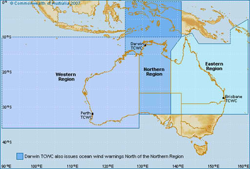
Where are Tropical Cyclone Forecast Track Maps issued?
Tropical Cyclone Forecast Track Maps are issued by Regional Offices of the Bureau of Meteorology in Brisbane, Darwin or Perth, depending on the location of the cyclone:

